|
|
Bikes |
|
Rides City Day trips Road trips |
|
Links |
Mt. Rainier and Columbia All-American Roads loop
 This ride takes 3 days of 200-250 miles per day, traveling through varied scenery, and over two of the All-American Roads. The National Scenic Byways program recognizes roads based on one or more archeological, cultural, historic, natural, recreational and scenic qualities. If a road has two or more of these qualities, it is called an All-American road. The first two days of this trip each cover one of these roads, first the Mather Memorial Parkway over Mt. Rainier, then the Historic Columbia River Highway along the Oregon side of the Columbia. The last day covers the backroads paralleling I-5 from Portland to Tacoma.
Day One - Mather Memorial Parkway
 Starting from Seattle, head South on I-5 to I-405. Take I-405 to Hwy 167 (Valley Fwy) South to Auburn. Take Hwy 18 East, then Hwy 164 (Auburn Way S) South to Enumclaw.
Now the ride really begins. From Enumclaw, take Hwy 410 (Mather Memorial Parkway). This winds through the foothills and forests, passing through Federation Forest State Park before turning South towards Mt. Rainier. Immediately after Federation Forest State Park is the town of Greenwater, which is the last place to fuel up (in case you didn't fuel up in Enumclaw) before entering Mt. Rainier National Park (there is no fuel inside the park boundaries, and the next place to fuel up is in Naches, 95 miles from Enumclaw).
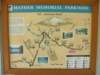
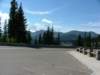
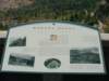
Prior to entering Mt. Rainier National Park, there is a great interpretive viewpoint with views of Mt. Rainier to the South and information on the Mather Memorial Parkway:
 |
 |
 |
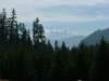 |
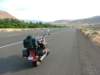
 Passing Crystal Mountain (a favorite wintertime ski resort), the road enters the National Park. Wandering through the forest, the road comes to a junction - take the left (heading East) to continue on Hwy 410 and go over Chinook Pass. This involves climbing a spectacular set of switchbacks, with magnificent views of Mt. Rainier and down the sheer cliff that you just rode up.
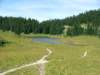
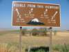
At the top of the main switchback is a great rest stop, with an alpine valley trailhead to the northeast, and views of the mountain to the Southwest:
 |
 |
 |
 |
 |
From here, the road goes up a couple of smaller switchbacks, then drops down to the East, taking a long, slowly dropping slope towards the Yakima Valley. The next large town along the route is Naches, from here take Hwy 12 East to Yakima.
 Naches or Yakima are great places to stop, fuel up the bike, and grab a bite to eat.
From here, take I-82 East (actually going South), then take Hwy 97 South. This road travels through the Yakima Indian Reservation, first through farmland, then up into the Simcoe Mountains.
Just past the borders of the reservation, coming down from the mountains, is Brooks Memorial State Park. There is a well-appointed campground, and this is a good place to settle down for the night.
Naches or Yakima are great places to stop, fuel up the bike, and grab a bite to eat.
From here, take I-82 East (actually going South), then take Hwy 97 South. This road travels through the Yakima Indian Reservation, first through farmland, then up into the Simcoe Mountains.
Just past the borders of the reservation, coming down from the mountains, is Brooks Memorial State Park. There is a well-appointed campground, and this is a good place to settle down for the night.
The road through these mountains is a mix of scrub and lush greenery. The RV spots at Brooks Memorial seem to fill up quite quickly, but there seem to be very few tents using the campsites:
 |
 |
Day Two - Historic Columbia River Highway
 From Brooks Memorial, continue South on Hwy 97. The road passes through Goldendale, then drops down into the Columbia River Gorge.
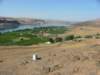
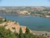
The scenery here is scrubland, with viewpoints of some great washout valleys. Before the bridge crossing the river (the town of Maryhill), take a left and follow the signs to "Stonehenge". This short detour goes to a full-size replica of Stonehenge built by Sam Hill around the turn of the 20th Century. This site also has a great view of the Gorge:
 |
 |
 |
 |
 |
 |
Going back to Hwy 97 and crossing the bridge over the Columbia River, take a right on the Oregon side to I-84/Hwy 30. From here to Portland, I-84 is the main freeway, running along the South side of the River. The Historic Columbia River Highway (Hwy 30) spurs off and parallels I-84 at various points along the way. The two main stretches are from just after The Dalles to Mosier at the East end and from Dodson to Troutdale at the West end.
Riding towards The Dalles along I-84, Mt. Hood looms large in front of the road:
 |
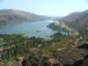
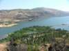
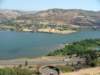
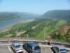
Just after the Dalles, the road quickly climbs to a peak via the Rowena Loops. This is a great vantage point over the Gorge:
 |
 |
 |
 |
 |
From here, the road continues west, and drops back to meet I-84 at Mosier. A few miles later, Hwy 30 takes a quick detour through Hood River - an enjoyable little town to drive through or stop and have lunch at.
 After Hood River, it's about 30 miles on I-84, past Cascade Locks and the Bridge of the Gods, to Dodson.
From here, Hwy 30 passes many waterfalls, including Multnomah Falls, the second highest year-round waterfall in the United States, dropping 620 feet. Go slow, watch out for tourists, and stop and join in to enjoy the waterfalls:
 |
 |
 |
 |
 |
 |
 |
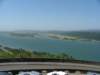
Continuing along Hwy 30 to the west, the road leaves most of the tourists behind at the waterfalls, and climbs to another pinnacle with a tower building, offering another breathtaking vantage point over the Columbia River Gorge:
 |
 |
 |
And this concludes the second day and the second All-American Road for this trip.
For the trip that the pictures on this page are from, the author took an extra day to visit relatives South of Portland. For the three-day loop described here, one would need to find a good resting place in the vicinity of Portland - don't worry, many exist, from state parks in the vicinity to the many lodging opportunities within Portland.
Day Three - Heading Home, Parallel to I-5
 The last day, head back to Seattle from Portland. Being against harsh concrete freeways on a bike, it is possible to make this trip staying on a network of highways all the way from Portland to Tacoma (this is a similar route to that taken by the Seattle-to-Portland bicycle trip). The only drawback to this is that in many of the towns, there is no good signage as to where the next highway exits the town. If you have a GPS on your bike, this is hopefully not a problem, but if you are using dead reckoning, you might take a few wrong turns along the way...
From Portland, take Hwy 30 West (actually heading North, paralleling the West side of the Northward bend in the Columbia) to the town of Rainier, where the Columbia turns back West toward the sea. At Rainier, head North on Hwy 433 over the Lewis and Clark Bridge to the town of Longview.
 Head North through Longview and onto Hwy 411 (Westside Hwy) North. Take this past Castle Rock to Vader. From Vader, take the Vader-Winlock road North to Winlock (surprise). From Winlock, take Hwy 603 North to Napavine. Continue North on Hwy 603 until it meets with Hwy 6. Take Hwy 6 East to Chehalis. From Chehalis, take National Ave. North to Centralia. Centralia or Chehalis are good places to stop for lunch.
From Centralia, take Tower Ave./Pearl St. (what National Ave. from Chehalis transitioned into) North out of town. This will transition into Hwy 507 (Bucoda Hwy).
 Continue North (sometimes East or Northeast) on Hwy 507 through the towns of Tenino, Rainier, Yelm, and Roy, connecting to Hwy 7 North through Spanaway to Hwy 512.
From here, there is a choice: Take Hwy 512 West a short spur to I-5 North, or head East on Hwy 512 to Hwy 161, Hwy 167 North, then I-405 South to I-5 North. Either way ends the trip back home in Seattle.
Happy Trails!
©2005-2021 Buccaneer Bikers
Images ©2005-2021 their respective BB member,
except maps ©one or more of: NAVTEQ, Google, Microsoft, USGS.